We have 1028 days left


Misslizard wrote:
Maybe it’s just worse in some areas.
https://247wallst.com/special-report/20 ... etime/amp/
https://247wallst.com/special-report/20 ... etime/amp/
And looking at another island mentioned there,
An uncertain future for Seychelles? Study shows sea levels are at their highest in the past 6,000 years
Victoria, Seychelles | October 19, 2014, Sunday @ 10:48 in Environment » CLIMATE | By: Hajira Amla
http://www.seychellesnewsagency.com/art ... +%2C+years
"
Seychelles, an archipelago of 115 granitic and coralline islands in the western Indian Ocean, is very susceptible to land loss due to rising sea levels, particularly as around 85 percent of the development in the Seychelles occurs along its coastline.
Just a one metre sea level increase in Seychelles could submerge many of the Seychelles’ low-lying coralline islands and inhabited coastal areas on the inner granitic islands, resulting in up to a 70 percent loss of the country’s total land mass.
Scientists have been at odds over Seychelles’ prognosis for rising global sea levels since 2010, with one camp arguing that it should have a minimal effect on the islands and groups of other researchers categorically refuting those claims, saying that the Seychelles should be “really, really worried” about sea level rise.
One thing that is certain is the two natural sources of protection against rising sea levels; namely coral reefs and mangrove forests, are already in trouble. Both shield the islands against soil erosion and serve as breeding grounds and natural habitats for fish.
Dense coastal development on some of the shorelines of the Seychelles islands poses a very real risk to the natural mangrove forests. When sea levels rise, the mangroves will be unable to retreat further back to re-establish themselves inland because of existing buildings and roads.
"
_________________
"There are a thousand things that can happen when you go light a rocket engine, and only one of them is good."
Tom Mueller of SpaceX, in Air and Space, Jan. 2011
kitesandtrainsandcats wrote:
Misslizard wrote:
Maybe it’s just worse in some areas.
That brings to mind,
Are sea levels rising the same all over the world, as if we're filling a giant bathtub?
No. Sea level rise is uneven, the two main reasons being ocean dynamics and Earth’s uneven gravity field.
https://sealevel.nasa.gov/faq/9/are-sea ... t-bathtub/
Is sea level the same all across the ocean?
The sea level varies around the globe.
https://oceanservice.noaa.gov/facts/globalsl.html
"
Most people are surprised to learn that, just as the surface of the Earth is not flat, the surface of the ocean is not flat, and that the surface of the sea changes at different rates around the globe. For instance, the absolute water level height is higher along the West Coast of the United States than the East Coast.
"
Oceans aren't rising everywhere — in some places they're actually falling
Sarah Kramer
Apr 25, 2016, 1:56 PM
https://www.businessinsider.com/why-sea ... ual-2016-4
Why Our Intuition About Sea-Level Rise Is Wrong
A geologist explains that climate change is not just about a global average sea rise.
By Daniel Grossman
February 9, 2016
https://nautil.us/why-our-intuition-abo ... g-rp-7522/
"
What happens when a big glacier like the Greenland Ice Sheet melts?
Three things happen. One is that you’re dumping all of this melt water into the ocean. So the mass of the entire ocean would definitely be going up if ice sheets were melting—as they are today. The second thing that happens is that this gravitational attraction that the ice sheet exerts on the surrounding water diminishes. As a consequence, water migrates away from the ice sheet. The third thing is, as the ice sheet melts, the land underneath the ice sheet pops up; it rebounds.
So what is the combined impact of the ice-sheet melt, water flow, and diminished gravity?
Gravity has a very strong effect. So what happens when an ice sheet melts is sea level falls in the vicinity of the melting ice sheet. That is counterintuitive. The question is, how far from the ice sheet do you have to go before the effects of diminished gravity and uplifting crust are small enough that you start to raise sea level? That’s also counterintuitive. It’s 2,000 kilometers away from the ice sheet. So if the Greenland ice sheet were to catastrophically collapse tomorrow, the sea level in Iceland, Newfoundland, Sweden, Norway—all within this 2,000 kilometer radius of the Greenland ice sheet—would fall. It might have a 30 to 50 meter drop at the shore of Greenland. But the farther you get away from Greenland, the greater the price you pay. If the Greenland ice sheet melts, sea level in most of the Southern Hemisphere will increase about 30 percent more than the global average. So this is no small effect.
"
Now what might the desalination of the ocean effect? Con: the specific gravity of saltwater versus diluted saltwater.
…effect on magnetic field of the earth? (Supposedly the global conveyor current that runs in the Atlantic Ocean
Might be slowing down. Which affects climate change?)
…….. [Please excuse my random ,above offering.] …
_________________
Diagnosed hfa
Loves velcro,
Quote:
where ever you go ,there you are
Jakki wrote:
Now what might the desalination of the ocean effect? Con: the specific gravity of saltwater versus diluted saltwater.
…effect on magnetic field of the earth? (Supposedly the global conveyor current that runs in the Atlantic Ocean
Might be slowing down. Which affects climate change?)
…….. [Please excuse my random ,above offering.] …
…effect on magnetic field of the earth? (Supposedly the global conveyor current that runs in the Atlantic Ocean
Might be slowing down. Which affects climate change?)
…….. [Please excuse my random ,above offering.] …
Given your recent combination tornado sideswipe adventure and knee surgery I will excuse you - This Time - for using effect instead of affect in "Now what might the desalination of the ocean effect? ".
Honestly though, either effect or affect can be used there given effect's second meaning of to cause.
English is a sometimes rather strange mongrelized conglomeration of a language.
Anyway, the thing falls in to that category of stuff where I am aware it is a thing but always have to go look up specifics because they don't stick in my memory. Which may well be an effect of the various was the ME/CFS affects my mind.
And I'm in the mood today where looking up info about stuff I'm interested in is fun and fulfilling.
Ocean salinity: Climate change is also changing the water cycle
As the Earth is warming, the global water cycle amplifies. Researchers from the Chinese Academy of Science, ETH Zurich, the American National Center for Atmospheric Research, the University of St. Thomas and the Pennsylvania State University studying ocean salinity have found strong evidence of a substantial amplification of in the past 50 years.
09.09.2020 by Chinese Academy of Sciences / ETH Zurich
https://usys.ethz.ch/en/news-events/new ... cycle.html
"
The meaning of salinity change
The study, published in Journal of Climate, overcomes many of the previous limitations, and derives an estimate of water cycle change based on a new salinity data product since 1960. From this, they provided strong evidence that the global water cycle has amplified substantially in the past 50 years, confirming theory and models. The study is led by Lijing Cheng from Institute of Atmospheric, Chinese Academy of Sciences, who collaborated with a group of international scientists from National Center for Atmospheric Research, U.S.; University of St. Thomas, U.S.; Pennsylvania State University, U.S, and ETH Zurich, namely Prof. Nicolas Gruber from the Department of Environmental Systems Science.
Changes in ocean salinity change can be used to estimate changes in Earth’s water cycle, because salinity variations very sensitively reflect the net exchange of freshwater between the ocean and the atmosphere. “Evaporation takes freshwater from the ocean into the atmosphere and increases the ocean salinity; precipitation puts freshwater into the ocean and reduces its salinity. Consequently, salinity changes integrate effects over broad areas and provide an excellent indicator for water cycle change.” Lijing Cheng introduced.
"
Lawrence Livermore National Laboratory
Science & Technology Review
December 2015
Clues to Climate Change in Ocean Salinity
https://str.llnl.gov/december-2015/durack
"
An international team of researchers led by Livermore oceanographer Paul Durack is showing how changes in ocean salinity can provide a robust method to understand observed changes in the global water cycle. The team has shown that ocean salinity levels provide a sensitive gauge for monitoring how large-scale patterns of precipitation and evaporation—the most important climate variables—are changing as a result of Earth’s rising surface temperatures, which have increased by an average of more than 0.5 degree Celsius since 1950. The long-range consequences are likely to include more violent storms, more severe flooding, and more intense droughts, which are already at problematic levels in California and elsewhere.
In a far-reaching study, the scientists combined more than 2 million observations of ocean salinity with more than 370 simulations conducted with climate models running on supercomputers to mimic atmospheric and oceanic processes, including precipitation, evaporation, and the resultant changes to ocean salinity. The findings suggest that since 1950, ongoing climate change has caused the entire global water cycle to intensify. Intensification is characterized by greater rainfall over some ocean areas, which is locally reducing salinity, and by increased evaporation in other parts of the sea, making those areas saltier. In short, oceanic salinity is changing approximately twice as much as had been predicted by the current generation of climate models.
Funded by the Regional and Global Climate Modeling Program in the Department of Energy’s Office of Science, Durack has been researching ocean salinity since 2011 together with scientists from Australia’s Commonwealth Scientific and Industrial Research Organisation (CSIRO). The project is one of several Livermore efforts devoted to understanding and predicting climate change by combining observational data with powerful climate-simulating models developed by researchers worldwide, including Livermore atmospheric scientists.
"
North Atlantic Is Getting Less Salty, But It’s Too Soon to Blame Climate Change
Continued decline could impact fish stocks, ocean’s ability to absorb CO2
by Kim Martineau | March 13, 2018
https://news.climate.columbia.edu/2018/ ... reshening/
"
Salinity in the North Atlantic dropped dramatically over the last decade, according to a new study that used data from a floating network of sensors to get the most detailed picture yet of changing ocean conditions in the region.
But researchers say it’s too soon to say whether the decline is due to an influx of freshwater from melting ice on land or sea, or part of a natural, longer term cycle. A research team at Columbia University’s Lamont-Doherty Earth Observatory and Johns Hopkins University published the results in the Journal of Climate’s April issue.
"
_________________
"There are a thousand things that can happen when you go light a rocket engine, and only one of them is good."
Tom Mueller of SpaceX, in Air and Space, Jan. 2011

Matrix Glitch wrote:
Mountain Goat wrote:
Matrix Glitch wrote:
I've lived by the sea going back nearly 30 years. High tide is at the same level it's always been.
I have for 50 years and whilst the sands are changing and have chqnged a fair bit (Which was expected) apart from the odd storm which can give the shores a hammering, the basic sea levels have stayed the same. There is a town near here where about a quarter of it was built below sea level and yet it still remains there with no problems. The Victorian engineers were great at what they did. They put in a series of one way flood defenses to make themselves land to use. Here is one of the two places in the world that has the greatest distance between the highest and lowest tides., so when the tide goes out, it goes right out and vice versa. They used this to their advantage to keep the land they reclaimed dry. Then the town was built upon it. No one dared build there before because it was hit by a few tsunamis in the past which repeated around every 400 years though the odd one hit at 200 year interval compared to the usual 400. The last tsunami was in 1607 (Or 1609?) and a great many people living in the coastal areas of South Wales and England lost their lives, though what saved many peoples lives was the fact in those days, many people lived inland due to the tsunami past and due to the African pirate slave traders who would take people from the UK and European shores.
My local village has houses where there are water marks just beliow first floor ceiling level where the tsunami hit, and it left a series of inland sand dunes when the water went back out which were not there before. Where I lived in the village, if we dug down about 8 to 12 ft, there was a thick band of sea shells deposited there after the tsunami.
But as to general sea levels, if anything it has receeded slightly rather than got any higher.
Someone mentioned the Norfolk (Along with Dover) area. This has NOTHING whatsoever to do with sea level rises. That area is built on chalk and once was joined with Europe. That has been erroding for years simply because the rocks and the chalk can't cope with the sea errosion. The other side of the UK has had more land given to it by the sea. Where I live, if I look at maps dating back to the late 1800's, the tide line is about half a mile further back and our beach is an extra few miles longer. This is natural. The tideline has receeded a lot which is evidence that global warming causing the sea levels to rise is total garbage.
In the 1890s where I'm at they dredged a channel or something and used all the sand to build a long thin "island". The land is barely above sea level. Yet it hasn't gone under.

To be fair there's plenty of photos from reputable sources that show inundation has began. Ask the residents of any small low lying island in the Pacific and Indian ocean and they will tell you it's already happening.
kitesandtrainsandcats wrote:
Eventually found news item which linked to the following page which is said to include commentary from the gal herself on the protest organization's website.
French is not a language I know.
https://derniererenovation.fr/
French is not a language I know.
https://derniererenovation.fr/
Typical French. The group make a global statement about their cause and the coming global apocalypse but they refuse to have an English version of their site

cyberdad wrote:
Matrix Glitch wrote:
Mountain Goat wrote:
Matrix Glitch wrote:
I've lived by the sea going back nearly 30 years. High tide is at the same level it's always been.
I have for 50 years and whilst the sands are changing and have chqnged a fair bit (Which was expected) apart from the odd storm which can give the shores a hammering, the basic sea levels have stayed the same. There is a town near here where about a quarter of it was built below sea level and yet it still remains there with no problems. The Victorian engineers were great at what they did. They put in a series of one way flood defenses to make themselves land to use. Here is one of the two places in the world that has the greatest distance between the highest and lowest tides., so when the tide goes out, it goes right out and vice versa. They used this to their advantage to keep the land they reclaimed dry. Then the town was built upon it. No one dared build there before because it was hit by a few tsunamis in the past which repeated around every 400 years though the odd one hit at 200 year interval compared to the usual 400. The last tsunami was in 1607 (Or 1609?) and a great many people living in the coastal areas of South Wales and England lost their lives, though what saved many peoples lives was the fact in those days, many people lived inland due to the tsunami past and due to the African pirate slave traders who would take people from the UK and European shores.
My local village has houses where there are water marks just beliow first floor ceiling level where the tsunami hit, and it left a series of inland sand dunes when the water went back out which were not there before. Where I lived in the village, if we dug down about 8 to 12 ft, there was a thick band of sea shells deposited there after the tsunami.
But as to general sea levels, if anything it has receeded slightly rather than got any higher.
Someone mentioned the Norfolk (Along with Dover) area. This has NOTHING whatsoever to do with sea level rises. That area is built on chalk and once was joined with Europe. That has been erroding for years simply because the rocks and the chalk can't cope with the sea errosion. The other side of the UK has had more land given to it by the sea. Where I live, if I look at maps dating back to the late 1800's, the tide line is about half a mile further back and our beach is an extra few miles longer. This is natural. The tideline has receeded a lot which is evidence that global warming causing the sea levels to rise is total garbage.
In the 1890s where I'm at they dredged a channel or something and used all the sand to build a long thin "island". The land is barely above sea level. Yet it hasn't gone under.
To be fair there's plenty of photos from reputable sources that show inundation has began. Ask the residents of any small low lying island in the Pacific and Indian ocean and they will tell you it's already happening.
That is a small low lying island in the Pacific ocean.
Matrix Glitch wrote:
That is a small low lying island in the Pacific ocean.
I don't know why some places are being inundated and others are not? But if NASA report global temperature rise then its hard to ignore
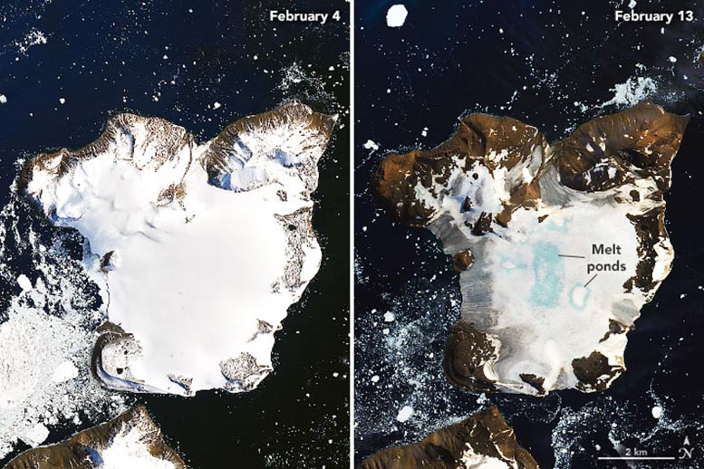
https://scitechdaily.com/dramatic-melti ... te-images/
The excess water from ice melt has to go somewhere
cyberdad wrote:
Matrix Glitch wrote:
That is a small low lying island in the Pacific ocean.
I don't know why some places are being inundated and others are not? But if NASA report global temperature rise then its hard to ignore
https://scitechdaily.com/dramatic-melti ... te-images/
The excess water from ice melt has to go somewhere
Those coastlines look exactly the same in both pictures.
Ice and snow has always melted. What does that spot look like right now? Go on Google Maps or Earth and take a look at its current condition.
Last edited by Matrix Glitch on 12 Jun 2022, 10:37 pm, edited 1 time in total.
Matrix Glitch wrote:
cyberdad wrote:
Matrix Glitch wrote:
That is a small low lying island in the Pacific ocean.
I don't know why some places are being inundated and others are not? But if NASA report global temperature rise then its hard to ignore
https://scitechdaily.com/dramatic-melti ... te-images/
The excess water from ice melt has to go somewhere
Those coastlines look exactly the same in both pictures.
It's the glacial ice that's the problem
Your own government is saying sea levels are rising
https://oceanservice.noaa.gov/facts/sealevel.html
cyberdad wrote:
Matrix Glitch wrote:
cyberdad wrote:
Matrix Glitch wrote:
That is a small low lying island in the Pacific ocean.
I don't know why some places are being inundated and others are not? But if NASA report global temperature rise then its hard to ignore
https://scitechdaily.com/dramatic-melti ... te-images/
The excess water from ice melt has to go somewhere
Those coastlines look exactly the same in both pictures.
It's the glacial ice that's the problem
You were saying coastlines are the problem due to rising sea levels. Yet the images you posted shows no change to the coastline due to rising sea levels, even where the ice is melting.
As for ice, it comes and goes.
What does that spot look like right now? Go on Google Maps or Earth and take a look at its current condition.
Edit: From the article, "About 20 percent of seasonal snow accumulation in the region melted in this one event on Eagle Island".
Oh noes seasonal snow accumulation is melting!
Matrix Glitch wrote:
As for ice, it comes and goes.
What does that spot look like right now? Go on Google Maps or Earth and take a look at its current condition.
Edit: From the article, "About 20 percent of seasonal snow accumulation in the region melted in this one event on Eagle Island".
Oh noes seasonal snow accumulation is melting!
What does that spot look like right now? Go on Google Maps or Earth and take a look at its current condition.
Edit: From the article, "About 20 percent of seasonal snow accumulation in the region melted in this one event on Eagle Island".
Oh noes seasonal snow accumulation is melting!
The photos are from NASA. I would expect they know what they are talking about. The data is fairly indisputable
https://climate.nasa.gov/vital-signs/sea-level/


We have climate refugees from the Marshall Islands.
https://www.sierraclub.org/sierra/2019- ... allese?amp
_________________
I am the dust that dances in the light. - Rumi
cyberdad wrote:
Matrix Glitch wrote:
As for ice, it comes and goes.
What does that spot look like right now? Go on Google Maps or Earth and take a look at its current condition.
Edit: From the article, "About 20 percent of seasonal snow accumulation in the region melted in this one event on Eagle Island".
Oh noes seasonal snow accumulation is melting!
What does that spot look like right now? Go on Google Maps or Earth and take a look at its current condition.
Edit: From the article, "About 20 percent of seasonal snow accumulation in the region melted in this one event on Eagle Island".
Oh noes seasonal snow accumulation is melting!
The photos are from NASA. I would expect they know what they are talking about. The data is fairly indisputable
https://climate.nasa.gov/vital-signs/sea-level/
And yet it's heavily disputed.
| Similar Topics | |
|---|---|
| How Many People Are Here These Days? |
18 Apr 2024, 12:50 pm |
| Building inner pressure for days feels like meltdown coming |
24 Feb 2024, 5:01 am |
| Genes Play a Very Small Role In Determining Left-Handedness |
21 Apr 2024, 4:54 pm |


