Tropical System Laura


ASPartOfMe
Veteran
![]()

Joined: 25 Aug 2013
Age: 66
Gender: Male
Posts: 34,478
Location: Long Island, New York
1. Laura is forecast to reach the northwestern Gulf Coast as a
hurricane late Wednesday and early Thursday. Do not focus
on the details of the official forecast given the typical
uncertainty in NHC's 2 to 3 day track and intensity predictions. In
addition, storm surge, wind, and rainfall hazards will extend well
away from Laura's center along the Gulf Coast.
2. There is a risk of life-threatening storm surge from San Luis
Pass, Texas, to Ocean Springs, Mississippi, within the next 48
hours, and a storm surge watch has been issued for these areas
outside of the southeast Louisiana Hurricane and Storm Damage Risk
Reduction System. Residents in these areas should follow any advice
given by local officials.
3. Hurricane conditions are possible by late Wednesday from Port
Bolivar, Texas, to west of Morgan City, Louisiana, with tropical
storm conditions possible by Wednesday afternoon, and a hurricane
watch has been issued. Additional hurricane watches may be needed
farther south along the Texas coast if the track forecast shifts
toward the south and west tonight and Tuesday.
4. Tropical storm conditions and heavy rainfall are expected across
central and western Cuba through tonight. These rains could cause
mudslides and life-threatening flash and urban flooding.
_________________
Professionally Identified and joined WP August 26, 2013
DSM 5: Autism Spectrum Disorder, DSM IV: Aspergers Moderate Severity
It is Autism Acceptance Month
“My autism is not a superpower. It also isn’t some kind of god-forsaken, endless fountain of suffering inflicted on my family. It’s just part of who I am as a person”. - Sara Luterman

So far, estimated landfall is Sabine Pass (Texas-Louisiana border), Cat. 3, Wednesday night/Thursday morning. I am in the Hurricane Watch area.
Even if the track holds, It's causing me great anxiety because it's so close, and because of Texas' piss-poor track record when it comes to climate change. Houston's urban sprawl makes things so much worse, should a future storm of comparable strength make a direct hit.
_________________
Who’s better at math than a robot? They’re made of math!
Now proficient in ChatGPT!
ASPartOfMe
Veteran
![]()
Joined: 25 Aug 2013
Age: 66
Gender: Male
Posts: 34,478
Location: Long Island, New York
near major hurricane intensity Wednesday night. Do not focus on the
details of the official forecast given the typical uncertainty in
NHC's track and intensity predictions. Storm surge, wind, and
rainfall hazards will extend well away from Laura's center along the
Gulf Coast.
2. There is the danger of life-threatening storm surge accompanied
by large and dangerous waves from San Luis Pass, Texas, to the Mouth
of the Mississippi River, including areas inside the Port Arthur
Hurricane Flood Protection system. A Storm Surge Warning is in
effect and residents should follow any advice given by local
officials. Actions to protect life and property should be rushed to
completion today, as water levels will begin to rise Wednesday.
3. Hurricane conditions are expected by Wednesday evening in the
area from San Luis Pass, Texas, to west of Morgan City, Louisiana,
and a Hurricane Warning is in effect. Tropical storm conditions are
expected to begin in the warning area Wednesday afternoon.
4. The threat of widespread flash and urban flooding along with
small streams overflowing their banks will be increasing Wednesday
night into Thursday from far eastern Texas, across Louisiana, and
Arkansas. This will also lead to minor to isolated moderate river
flooding. The heavy rainfall threat will spread northeastward into
the middle-Mississippi, lower Ohio, and Tennessee Valleys Friday and
Saturday.
_________________
Professionally Identified and joined WP August 26, 2013
DSM 5: Autism Spectrum Disorder, DSM IV: Aspergers Moderate Severity
It is Autism Acceptance Month
“My autism is not a superpower. It also isn’t some kind of god-forsaken, endless fountain of suffering inflicted on my family. It’s just part of who I am as a person”. - Sara Luterman
Sweetleaf
Veteran
![]()

Joined: 6 Jan 2011
Age: 34
Gender: Female
Posts: 34,470
Location: Somewhere in Colorado


Hurricane Laura forecast to be Category 4 storm as Texas, Louisiana brace for landfall
Storm surge from Laura could reach up to 30 miles inland.
An intensifying Hurricane Laura is growing stronger by the hour Wednesday over the Gulf of Mexico as forecasters warn the powerful system will be a "catastrophic” Category 4 storm before it makes landfall along the Gulf Coast.
The U.S. National Hurricane Center (NHC) in Miami said Wednesday morning that Laura, now a major hurricane, is forecast to "rapidly strengthen" throughout the day, bringing life-threatening storm surge, extreme winds, and flash flooding over eastern Texas and Louisiana.
As of 8 a.m. EDT, the storm is located about 280 miles south-southeast of Lake Charles, Louisiana, moving northwest at 15 mph with maximum sustained winds of 115 mph.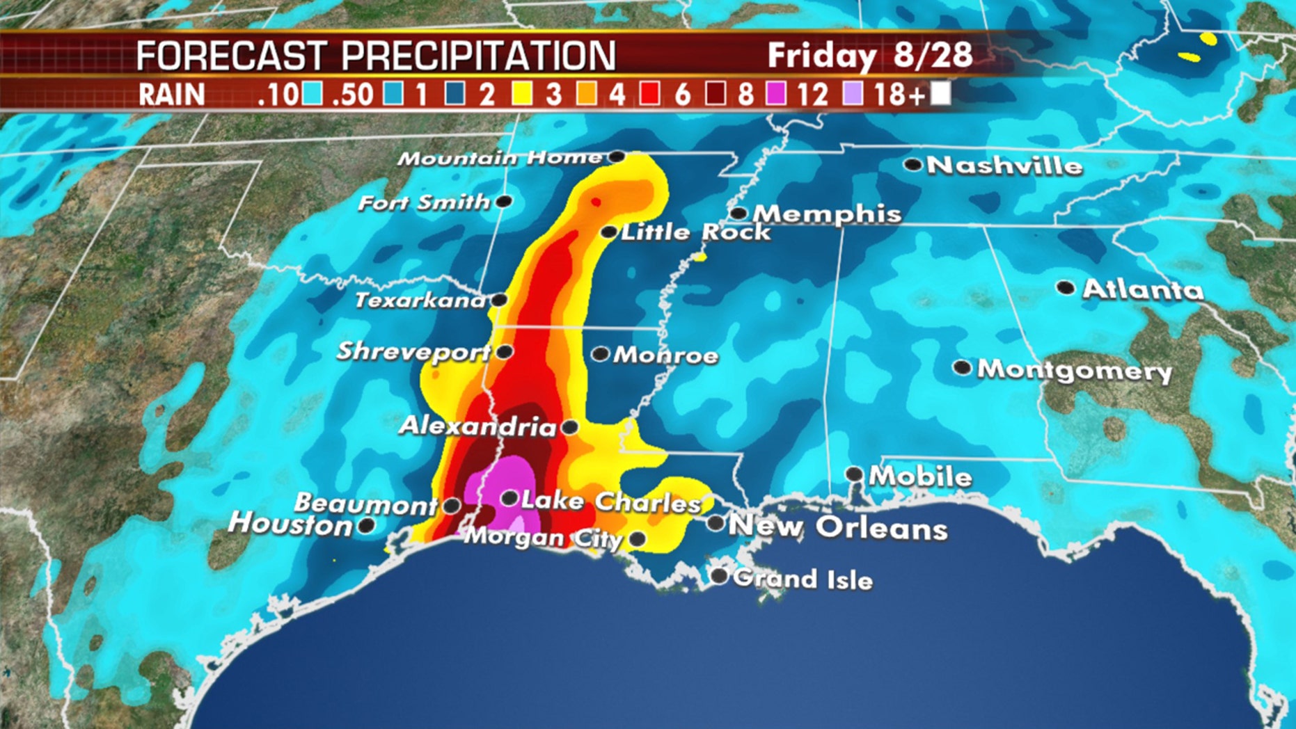
Laura is forecast to make landfall as a major hurricane with winds upwards of 115 mph on the border between Texas and Louisiana early Thursday morning, but conditions are going to go downhill through the day on Wednesday.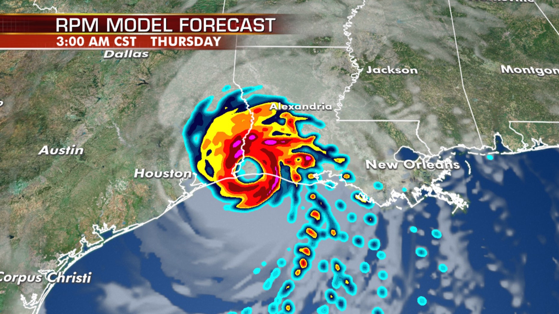
Source: Hurricane Laura forecast to be Category 4 storm as Texas, Louisiana brace for landfall
_________________
Author of Practical Preparations for a Coronavirus Pandemic.
A very unique plan. As Dr. Paul Thompson wrote, "This is the very best paper on the virus I have ever seen."
Hurricane Laura forces evacuations of over half a million in Texas, Louisiana ahead of landfall
Hurricane Laura has forced evacuations of over half a million people in Texas and Louisiana ahead of its expected landfall along the Gulf Coast early Thursday.
More than 385,000 residents have been ordered to leave the Texas cities of Beaumont, Galveston and Port Arthur early Tuesday as the storm was forecast to bring life-threatening storm surge, extreme winds, and flash flooding.
In southwestern Louisiana, the low-lying Calcasieu Parish issued a mandatory evacuation of 200,000 residents. Forecasters said the area could see as much as 13 feet of storm surge with waves that could leave entire communities under water.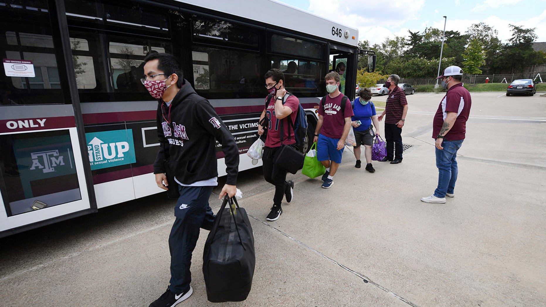
Source: Hurricane Laura forces evacuations of over half a million in Texas, Louisiana ahead of landfall
_________________
Author of Practical Preparations for a Coronavirus Pandemic.
A very unique plan. As Dr. Paul Thompson wrote, "This is the very best paper on the virus I have ever seen."
ASPartOfMe
Veteran
![]()
Joined: 25 Aug 2013
Age: 66
Gender: Male
Posts: 34,478
Location: Long Island, New York
national hurricane center wrote:
SUMMARY OF 1000 AM CDT...1500 UTC...INFORMATION
-----------------------------------------------
LOCATION...27.0N 92.0W
ABOUT 225 MI...365 KM SSE OF LAKE CHARLES LOUISIANA
ABOUT 235 MI...375 KM SE OF GALVESTON TEXAS
MAXIMUM SUSTAINED WINDS...125 MPH...205 KM/H
PRESENT MOVEMENT...NW OR 310 DEGREES AT 16 MPH...26 KM/H
MINIMUM CENTRAL PRESSURE...956 MB...28.23 INCHES
Key Messages:
1. Unsurvivable storm surge with large and destructive waves will
cause catastrophic damage from Sea Rim State Park, Texas, to
Intracoastal City, Louisiana, including Calcasieu and Sabine Lakes.
This surge could penetrate up to 30 miles inland from the immediate
coastline. Only a few hours remain to protect life and property and
all actions should be rushed to completion.
2. Hurricane-force winds are expected tonight in portions of the
hurricane warning area from San Luis Pass, Texas, to west of Morgan
City, Louisiana, with catastrophic wind damage expected where
Laura's eyewall makes landfall. Hurricane-force winds and
widespread damaging wind gusts will spread well inland across
portions of eastern Texas and western Louisiana early Thursday.
3. Widespread flash flooding along small streams, urban areas, and
roadways is expected to begin this afternoon into Thursday from far
eastern Texas, across Louisiana and Arkansas. This will also lead
to minor to isolated moderate freshwater river flooding. The heavy
rainfall threat and localized flash and urban flooding potential
will spread northeastward into the middle-Mississippi, lower Ohio
and Tennessee Valleys Friday night and Saturday.
As we have seen repeatedly over the last few years hurricanes tend to intensify very rapidly over the Gulf of Mexico. A few days ago there was hope that Laura would be shredded apart as the forecast had it going over the Dominican Republic and Cuba. Instead it traveled south of those islands over water making her primed and ready to be “fed” by the warm Gulf of Mexico waters.
_________________
Professionally Identified and joined WP August 26, 2013
DSM 5: Autism Spectrum Disorder, DSM IV: Aspergers Moderate Severity
It is Autism Acceptance Month
“My autism is not a superpower. It also isn’t some kind of god-forsaken, endless fountain of suffering inflicted on my family. It’s just part of who I am as a person”. - Sara Luterman
Tex and anyone else in this storm's path. If you are not in a high location and strong hurricane proof building, get out, as fast as you can. Do not wait until the last minute.
After wind speed hits 40 mph, no emergency crews will come out to help you until the storm is over. You can't drive a car in windspeeds like that.
Last I heard, it is forecast to be at Cat 5 by the time it hits.
Take care.
_________________
The river is the melody
And sky is the refrain - Gordon Lightfoot
ASPartOfMe
Veteran
![]()
Joined: 25 Aug 2013
Age: 66
Gender: Male
Posts: 34,478
Location: Long Island, New York
Oh s**t
BULLETIN
Hurricane Laura Intermediate Advisory Number 28A
NWS National Hurricane Center Miami FL AL132020
700 PM CDT Wed Aug 26 2020
...WINDS INCREASING AS EXTREMELY DANGEROUS HURRICANE LAURA TAKES AIM
AT THE NORTHWEST GULF COAST...
...CATASTROPHIC STORM SURGE, EXTREME WINDS, AND FLASH FLOODING
EXPECTED ALONG THE NORTHWEST GULF COAST TONIGHT...
SUMMARY OF 700 PM CDT...0000 UTC...INFORMATION
----------------------------------------------
LOCATION...28.4N 92.9W
ABOUT 120 MI...190 KM S OF LAKE CHARLES LOUISIANA
ABOUT 120 MI...190 KM SSE OF PORT ARTHUR TEXAS
MAXIMUM SUSTAINED WINDS...150 MPH...240 KM/H
PRESENT MOVEMENT...NNW OR 330 DEGREES AT 15 MPH...24 KM/H
MINIMUM CENTRAL PRESSURE...940 MB...27.76 INCHES
_________________
Professionally Identified and joined WP August 26, 2013
DSM 5: Autism Spectrum Disorder, DSM IV: Aspergers Moderate Severity
It is Autism Acceptance Month
“My autism is not a superpower. It also isn’t some kind of god-forsaken, endless fountain of suffering inflicted on my family. It’s just part of who I am as a person”. - Sara Luterman
I'm in Baton Rouge, so this storm has been making me nervous too. It's barely brushing past us to the west.
I live just east of Houston, and we hardly got any effects from Laura.
_________________
Who’s better at math than a robot? They’re made of math!
Now proficient in ChatGPT!
ASPartOfMe
Veteran
![]()
Joined: 25 Aug 2013
Age: 66
Gender: Male
Posts: 34,478
Location: Long Island, New York
Laura made landfall near Cameron,La earlier this morning with 150MPH winds
_________________
Professionally Identified and joined WP August 26, 2013
DSM 5: Autism Spectrum Disorder, DSM IV: Aspergers Moderate Severity
It is Autism Acceptance Month
“My autism is not a superpower. It also isn’t some kind of god-forsaken, endless fountain of suffering inflicted on my family. It’s just part of who I am as a person”. - Sara Luterman
| Similar Topics | |
|---|---|
| Medical Alert System |
30 Mar 2024, 2:27 pm |
| School system in Poland is really messed up. |
01 Feb 2024, 2:44 pm |


